
Hi friends, in this blog, we are going to discuss about an amazing and wonderful destination, the Biggest Natural Mirror in the World , Salar de Uyuni . We will feel this as an intersecting point of sky and earth. Please send your valuable comments and suggestions to improve ourselves …………………….
Salar de Uyuni (or Salar de Tunupa) is the world’s largest salt flat, or playa, at over 10,000 square kilometres (3,900 sq mi) in area. It is in the Daniel Campos Province in Potosí in southwest Bolivia, near the crest of the Andes at an elevation of 3,656 meters (11,995 ft) above sea level.
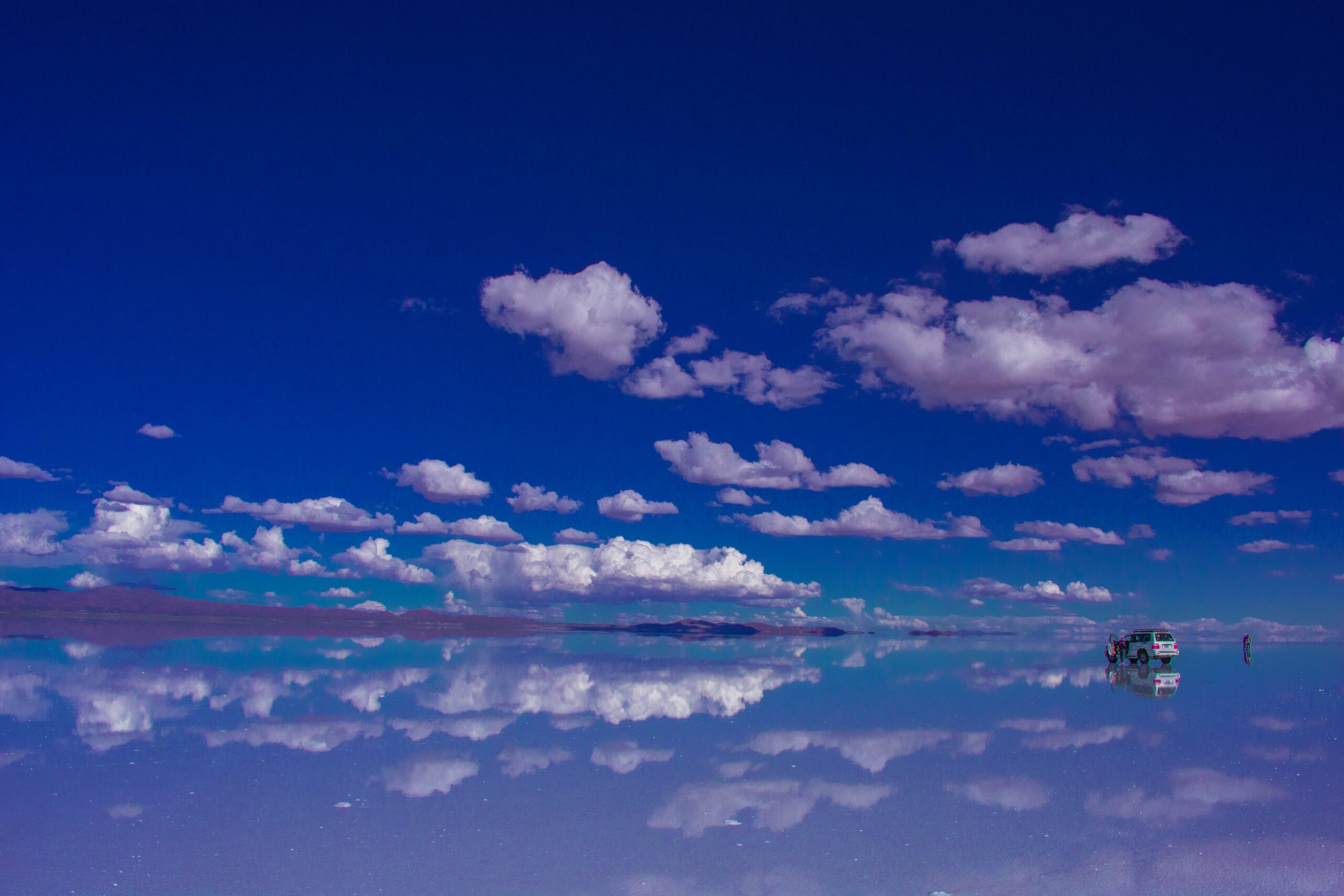
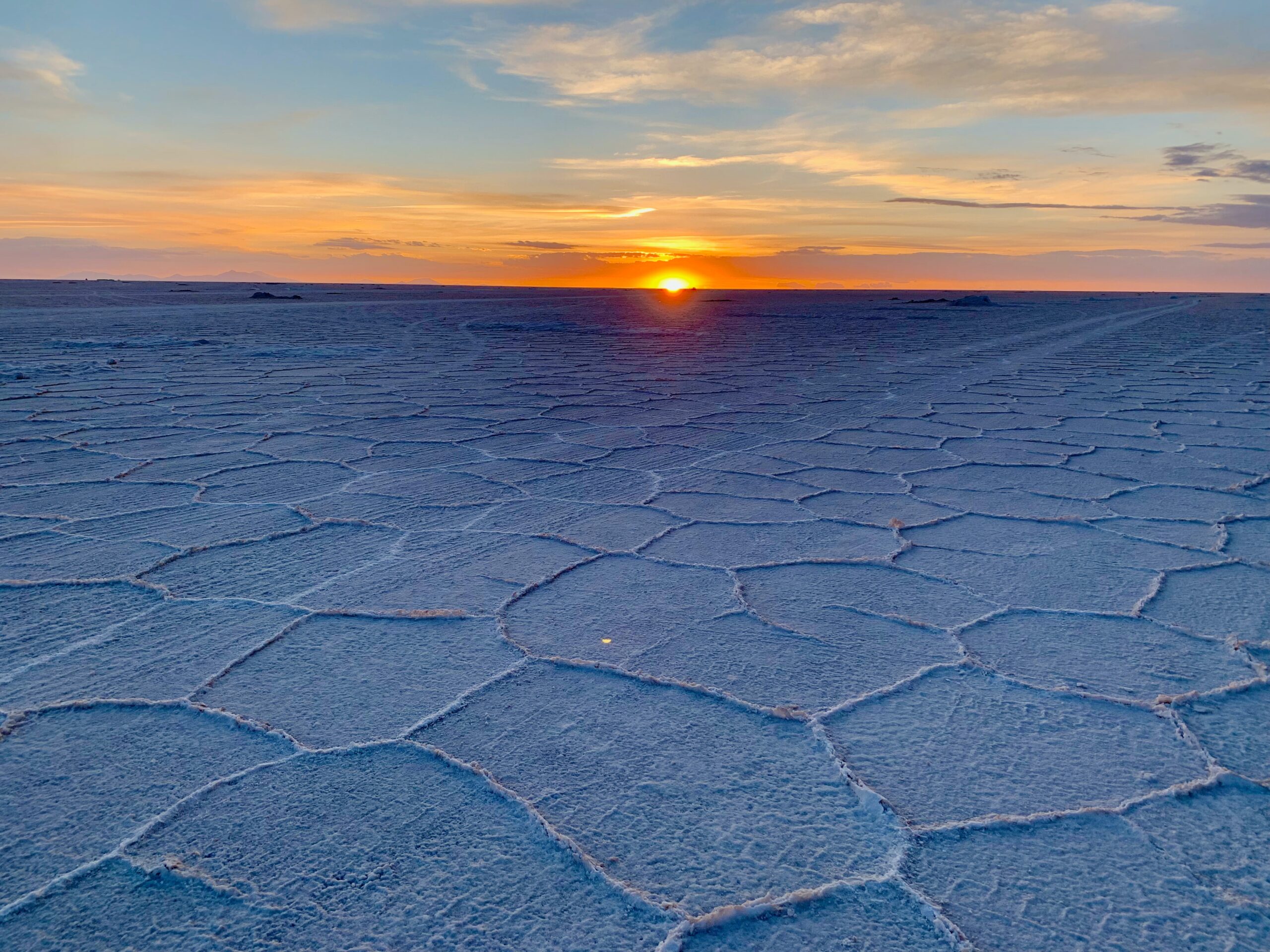
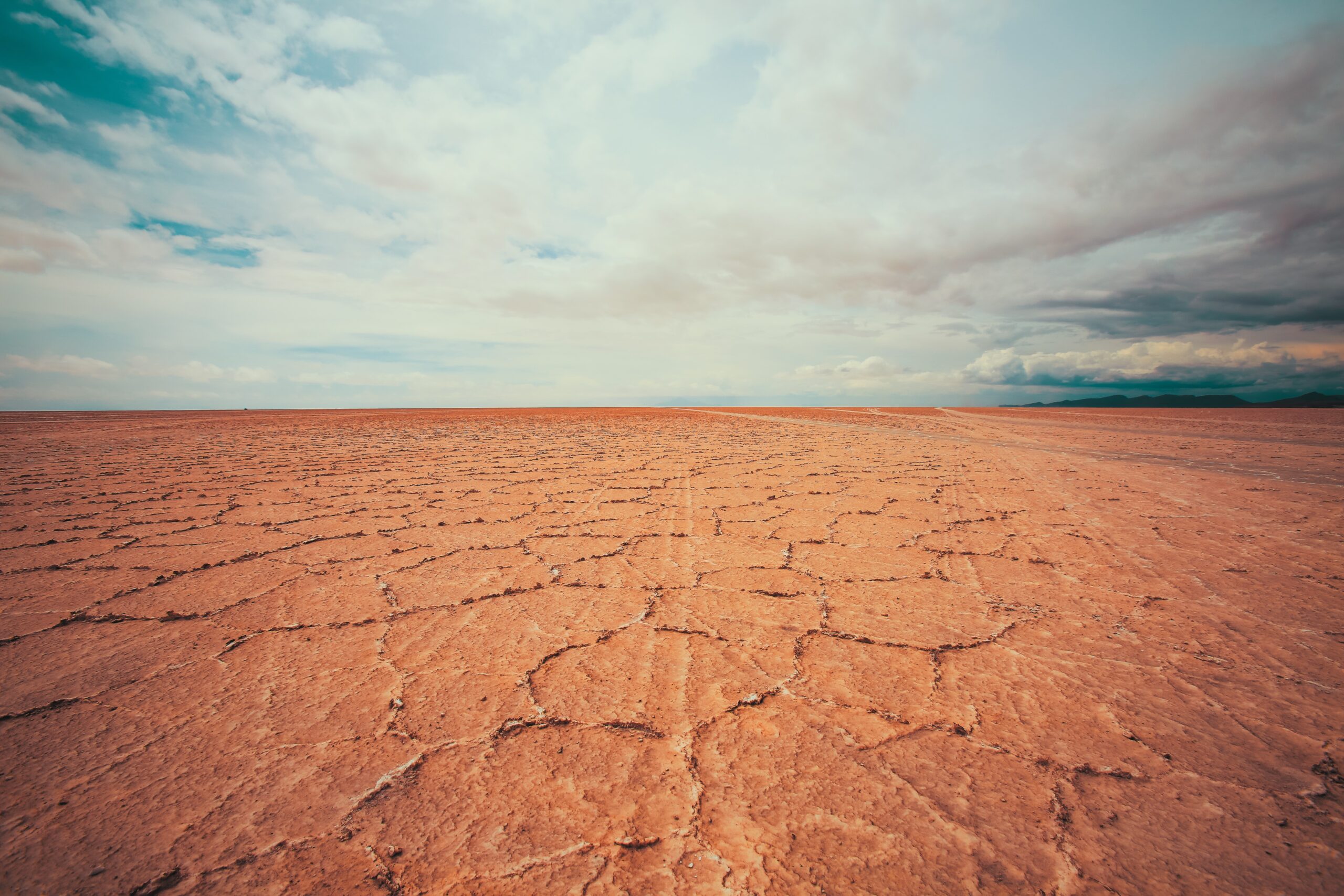
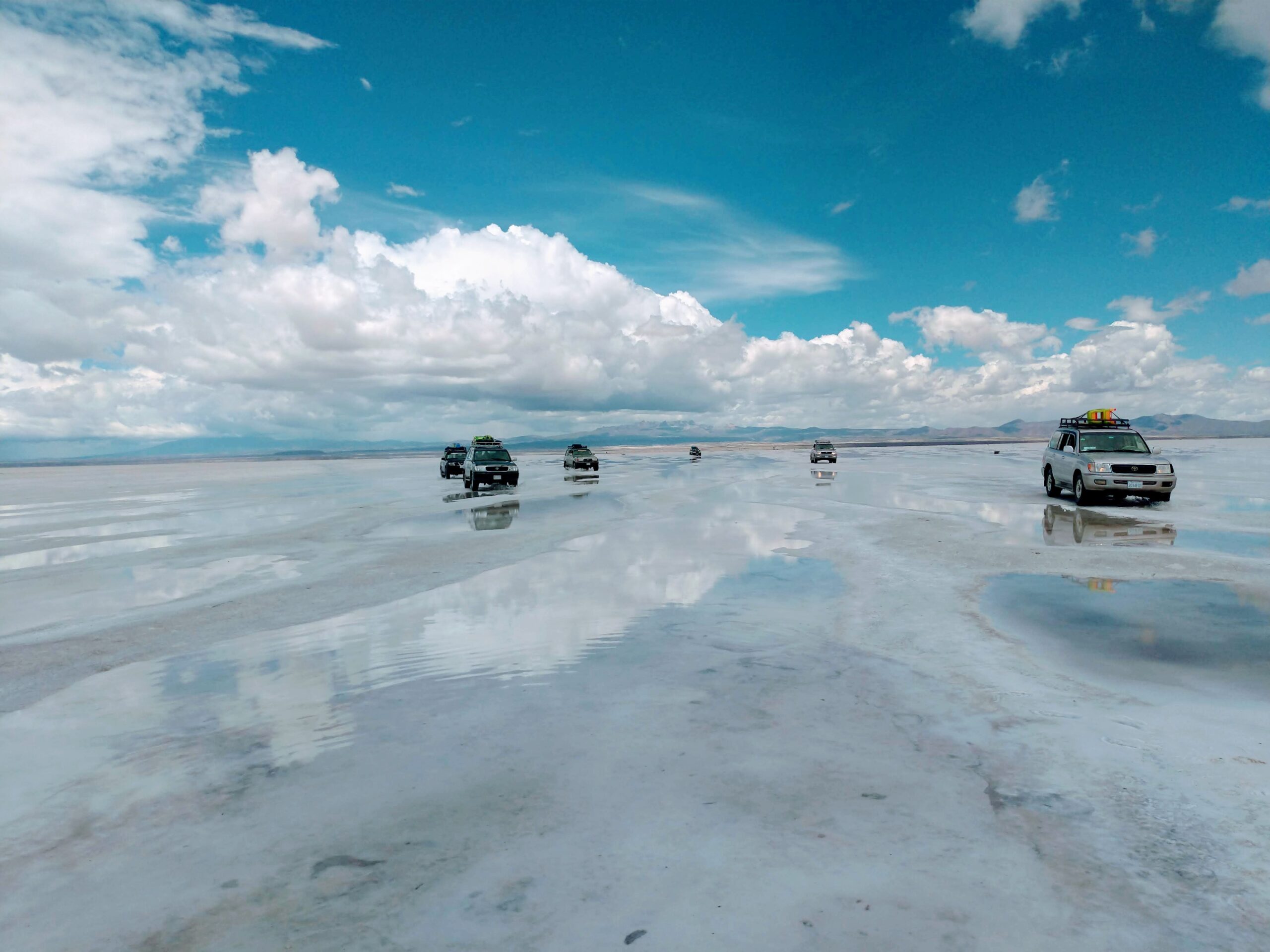
Bolivia’s Salar de Uyuni is considered one of the most extreme and remarkable vistas in all of South America. Stretching more than 4,050 square miles of the Altiplano, it is the world’s largest salt flat, left behind by prehistoric lakes evaporated long ago. Here, a thick crust of salt extends to the horizon, covered by quilted, polygonal patterns of salt rising from the ground.
At certain times of the year, nearby lakes overflow and a thin layer of water transforms the flats into a stunning reflection of the sky. This beautiful and otherworldly terrain serves as a lucrative extraction site for salt and lithium—the element responsible for powering laptops, smart phones, and electric cars. In addition to local workers who harvest these minerals, the landscape is home to the world’s first salt hotel and populated by road-tripping tourists. The harsh beauty and desolateness of Salar de Uyuni can make for an incredible experience or a logistical nightmare.
Here’s a guide to help:
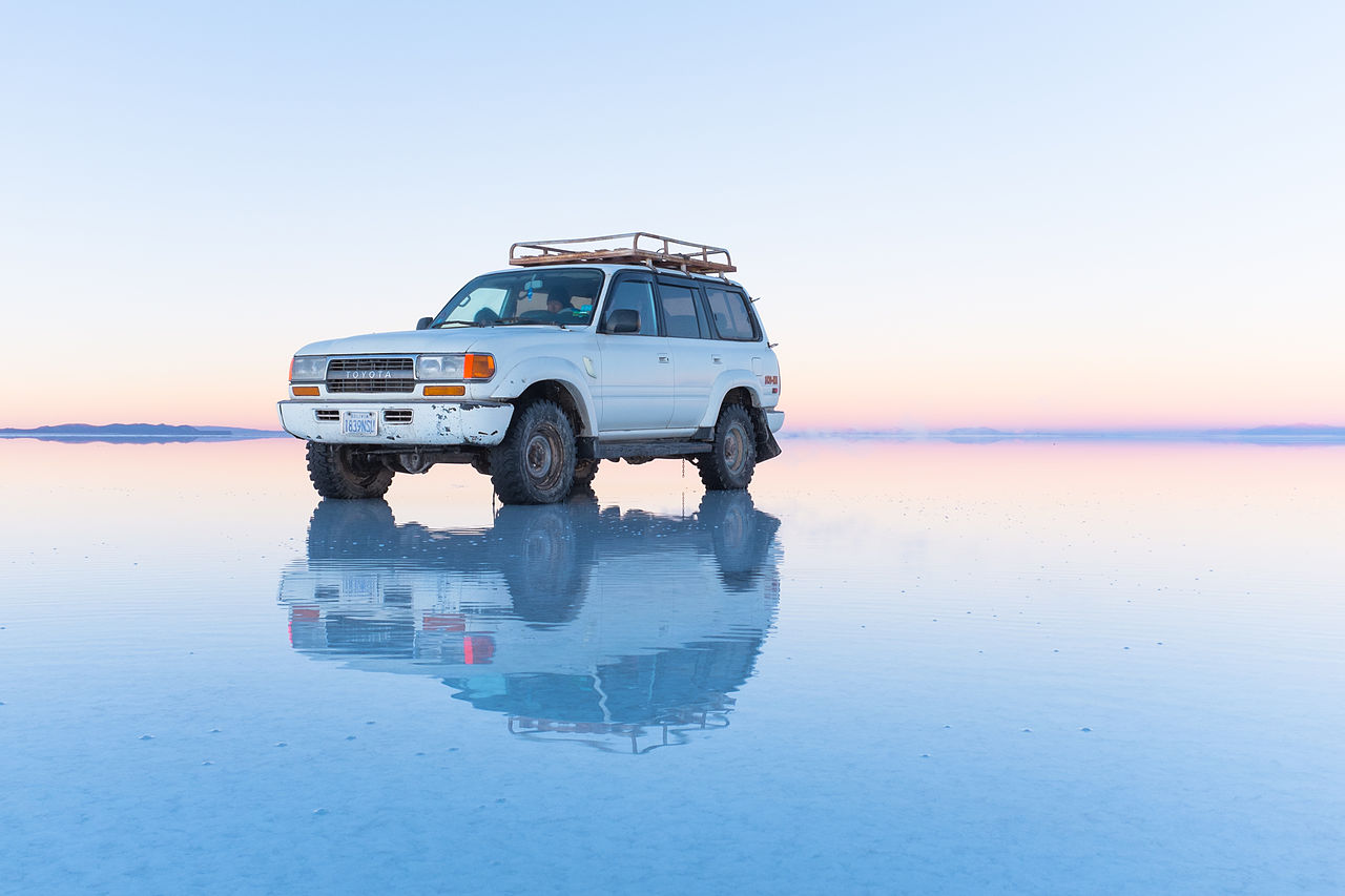
The Salar was formed as a result of transformations between several prehistoric lakes. It is covered by a few meters of salt crust, which has an extraordinary flatness with the average elevation variations within one meter over the entire area of the Salar. The crust serves as a source of salt and covers a pool of brine, which is exceptionally rich in lithium. It contains 50% to 70% of the world’s known lithium reserves according to a 2009 Foreign Policy article by Joshua Keating. The large area, clear skies, and exceptional flatness of the surface make the Salar ideal for calibrating the altimeters of Earth observation satellites. Following rain, a thin layer of dead calm water transforms the flat into the world’s largest mirror, 129 kilometers (80 miles) across.
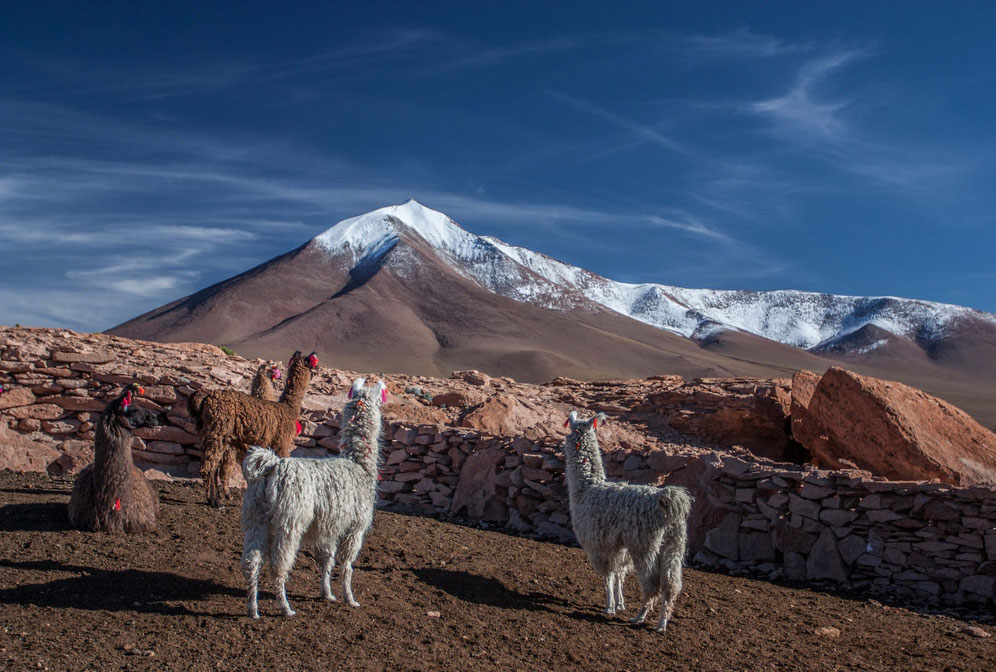
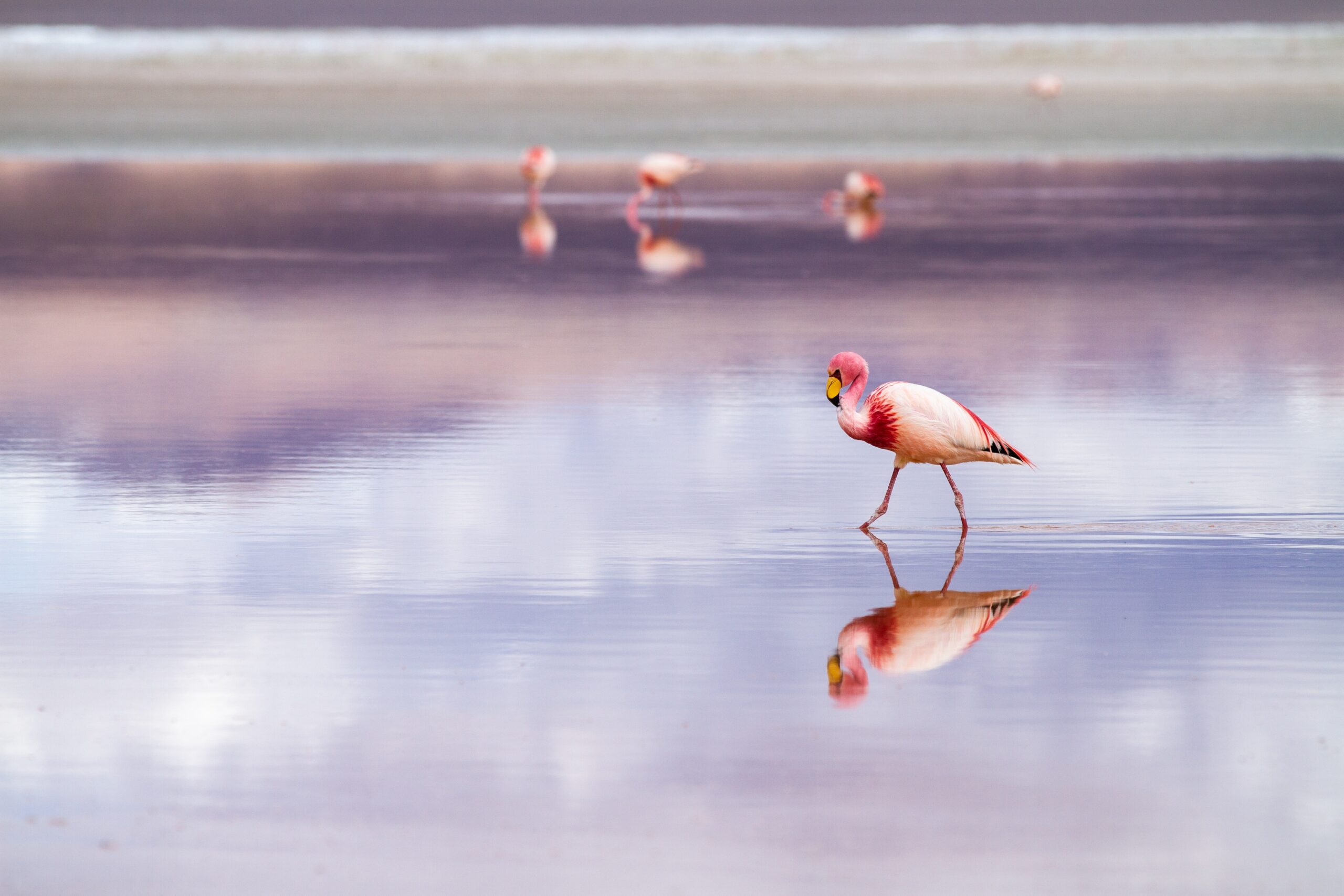
The Salar serves as the major transport route across the Bolivian Altiplano and is a prime breeding ground for several species of flamingos. Salar de Uyuni is also a climatological transitional zone since the towering tropical cumulus congestus and cumulonimbus incus clouds that form in the eastern part of the salt flat during the summer cannot permeate beyond its drier western edges, near the Chilean border and the Atacama Desert.
Salar has been used as a filming location for movies such as Star Wars The Last Jedi (2017) as planet Crait, The Fall (2006), Salt and Fire (2016), The Unseen (2017) and more Salar de Uyuni is part of the Altiplano of Bolivia in South America. The Altiplano is a high plateau, which was formed during uplift of the Andes mountains. The plateau includes fresh and saltwater lakes as well as salt flats and is surrounded by mountains with no drainage outlets.
The geological history of the Salar is associated with a sequential transformation between several vast lakes. Some 30,000 to 42,000 years ago, the area was part of a giant prehistoric lake, Lake Minchin. Its age was estimated by radiocarbon dating shells from outcropping sediments and carbonate reefs and varies between reported studies. Lake Minchin (named after Juan B. Minchin of Oruro[]) later transformed into Paleo Lake Tauca having a maximal depth of 140 meters , and an estimated age of 13,000 to 18,000 or 15,000 to 26,000 years, depending on the source. The youngest prehistoric lake was Coipasa, which was radiocarbon dated to 11,500 to 13,400 years ago. When it dried, it left behind two modern lakes, Poopó and Uru Uru, and two major salt deserts, Salar de Coipasa and the larger Salar de Uyuni. Salar de Uyuni spreads over 10,582 km2, which is roughly 100 times the size of the Bonneville Salt Flats in the United States. Lake Poopó is a neighbour of the much larger Lake Titicaca. During the wet season, Titicaca overflows and discharges into Poopó, which in turn, floods Salar De Coipasa and Salar de Uyuni.
Lacustrine mud that is interbedded with salt and saturated with brine underlies the surface of Salar de Uyuni. The brine is a saturated solution of sodium chloride, lithium chloride, and magnesium chloride in water. It is covered with a solid salt crust varying in thickness between tens of centimeters and a few meters. The center of the Salar contains a few islands, which are the remains of the tops of ancient volcanoes submerged during the era of Lake Minchin. They include unusual and fragile coral-like structures and deposits that often consist of fossils and algae.
The area has a relatively stable average temperature with a peak at 21 °C in November to January and a low of 13 °C in June. The nights are cold all through the year, with temperatures between −9 °C and 5 °C. The relative humidity is rather low and constant throughout the year at 30% to 45%. The rainfall is also low at 1 mm to 3 mm per month between April and November, but it may increase up to 80 mm in January. However, except for January, even in the rainy season the number of rainy days is fewer than 5 per month
The Salar contains a large amount of sodium, potassium, lithium and magnesium as well as borax. With an estimated 9,000,000 t, Bolivia holds about 7% of the world’s known lithium resources; most of those are in the Salar de Uyuni.
Lithium is concentrated in the brine under the salt crust at a relatively high concentration of about 0.3%. It is also present in the top layers of the porous halite body lying under the brine; however, the liquid brine is easier to extract, by boring into the crust and pumping out the brine. The brine distribution has been monitored by the Landsat satellite and confirmed in ground drilling tests. Following those findings, an American-based international corporation has invested $137 million to developing lithium extraction. However, lithium extraction in the 1980s and 1990s by foreign companies met strong opposition from the local community. Locals believed that the money infused by mining would not reach them. The lithium in the salt flats contains more impurities, and the wet climate and high altitude make it harder to process.
No mining plant is currently at the site, and the Bolivian government does not want to allow exploitation by foreign corporations. Instead, it intends to reach an annual production of 35,000 t by 2023 in a joint venture with ACI Systems Alemania GmbH.
Salar de Uyuni is estimated to contain 10 billion tonnes (9.8 billion long tons; 11 billion short tons) of salt, of which less than 25,000 t is extracted annually. All miners working in the Salar belong to Colchani’s cooperative.
Because of its location, large area, and flatness, the Salar is a major car transport route across the Bolivian Altiplano, except when seasonally covered with water.
The Salar is virtually devoid of any wildlife or vegetation. The latter is dominated by giant cacti. They grow at a rate of about 1 cm/a to a height of about 12 m. Other shrubs include Pilaya, which is used by locals to cure catarrh, and Thola which is burned as a fuel. Also present are quinoa plants and queñua bushes.
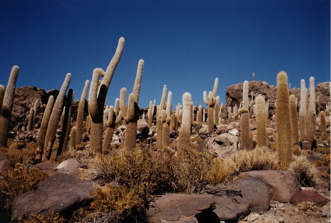
Every November, Salar de Uyuni is the breeding ground for three South American species of flamingo: the Chilean, Andean, and rare James’s flamingos. About 80 other bird species are present, including the horned coot, Andean goose, and Andean hillstar. The Andean fox, or culpeo, is also present, and islands in the Salar (in particular Incahuasi Island) host colonies of rabbit-like viscachas.
Tourism
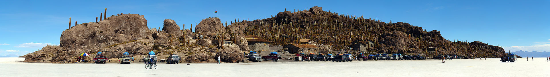
Salar de Uyuni attracts tourists from around the world. As it is far from the cities, a number of hotels have been built in the area. Due to lack of conventional construction materials, many of them are almost entirely (walls, roof, furniture) built with salt blocks cut from the Salar. The first such hotel, named Palacio de Sal, was erected in 1993–1995 in the middle of the salt flat, and soon became a popular tourist destination. However, its location in the center of a desert caused sanitation problems, as most waste had to be collected manually. Mismanagement caused serious environmental pollution and the hotel had to be dismantled in 2002.
One major tourist attraction is an antique train cemetery. It is 3 km outside Uyuni and is connected to it by the old train tracks. The town served in the past as a distribution hub for the trains carrying minerals en route to Pacific Ocean ports. The rail lines were built by British engineers arriving near the end of the 19th century and formed a sizeable community in Uyuni. The engineers were invited by the British-sponsored Antofagasta and Bolivia Railway Companies, now Ferrocarril de Antofagasta a Bolivia.
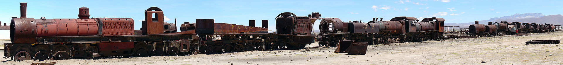
The rail construction started in 1888 and ended in 1892. It was encouraged by Bolivian President Aniceto Arce, who believed Bolivia would flourish with a good transport system, but it was also constantly damaged by the local Aymara indigenous Indians who saw it as an intrusion into their lives. The trains were mostly used by the mining companies. In the 1940s, the mining industry collapsed, partly because of mineral depletion. Many trains were abandoned, producing the train cemetery. There are proposals to build a museum from the cemetery.
HOW TO GET THERE
Located at the crux of Bolivia, Chile, and Argentina, the logistics and length of your trip to Salar de Uyuni will depend where you’re coming from. Tours originate from three main places:
Uyuni, Bolivia: The most popular jumping-off point for salt flats tours, Uyuni is a small, dusty town packed with tourism agencies in Plaza Arce, its main square. Travelers can book tours in advance online, through tour offices in La Paz, or they can simply arrive in Uyuni and peruse the options in town. Since Uyuni is so close to the salt flats, tourists can easily book day trips. Flights from La Paz to Uyuni can be booked through Amaszonas and BoA (one hour, about $130 round-trip). Overnight buses from La Paz are available with Trans Omar and Todo Turismo (10-12 hours, $30 to $40 each way).
San Pedro de Atacama, Chile: Agencies drive travelers to the border before handing the tour over to a Bolivian operator. Due to the distance, this is a three-day tour.
Tupiza, Bolivia: This is the best starting point for travelers coming from Argentina. Tour operators recommend four-day tours from Tupiza, visiting Salar de Uyuni on the final day.
Salar de Uyuni has two distinct seasons. The rainy season (December to April) is when visitors come to witness the Salar’s breathtaking mirror effect. Be wary of excessive rain in December and January, as it can cause tour cancelations. During the dry season (May to November) temperatures are colder, the ground has hardened, and travelers can drive across the stark white landscape to places that aren’t accessible in the rainy season. Tour operators consider June through August their high period, and rates may rise accordingly.

While the salt flats are one of Bolivia’s most popular attractions, it’s only a small part of the gorgeous Altiplano region. Many visitors indulge in a three-day tour (or longer) that includes the deserts, volcanos, geysers, hot springs, and high-altitude lakes to the south. Tours out of San Pedro de Atacama and Tupiza are already scheduled to drive through these sites.
Travelers can choose between a shared tour (cheaper and standardized) or private tour (higher-priced and custom-tailored). Shared tours generally provide Spanish-speaking guides who double as the driver and chef. These follow a rigid itinerary that will not likely accommodate individual requests and can hinder certain times of day, like sunrise or sunset. Private tours, by contrast, can be customized to a client’s liking, giving travelers more control over itinerary and the ability to go off the beaten path to volcanos or caves. Private tours also provide an English-speaking guide, chef, and a more comfortable vehicle.
Check online reviews and travel guides to carefully choose a reputable guide. Avoid companies that offer rock bottom prices—they may not provide an accredited guide or working car, which can endanger tourists. Also ask your agency whether they carry an emergency radio and first-aid kit.
HOW TO TAKE GREAT PHOTOS
One of the highlights of Salar de Uyuni is an endless horizon that allows photographers to play with perspective and depth of field. Stage battle scenes with toy dinosaurs, cook your friends in pots and pans, or crawl out of seemingly giant jars of peanut butter. The key to great photos is to get the camera low to the ground and close to your prop. This gives the perspective that the prop is larger than the human subjects, who stand farther away. Don’t let your subjects venture too far, though—the larger the distance between the prop and the subjects, the harder it will be to keep everything in focus.
At nearly 12,000 feet above sea level, visitors may experience altitude sickness if they haven’t properly acclimatized. Symptoms include nausea, headaches, and insomnia among others. Discuss various options for preventing and treating altitude sickness with your doctor before your trip.
Bolivia requires a tourist visa ($160 for U.S. citizens) as well as a Yellow Fever Vaccination Certificate to enter the country.
camera permits, make the aperture as narrow as possible.
Some Tips
Same type of salt flats we can see at Ouki ,an ancient lake in the Bolivian Altiplano, PUKA MAYU, Bolivian river in the Potosí Department, Nor Lípez Province, Colcha “K” Municipality, GREAT SALT LAKE ,located in the northern part of the U.S. state of Utah, is the largest salt water lake in the Western Hemisphere, and the eighth-largest terminal lake in the world, And The Rann of Kutch is a large area of salt marshes that span the border between Pakistan and India. It is located mostly in Gujarat, India and in some parts of Sindh, Pakistan. It is divided into the Great Rann and Little Rann.